
Do Property Values Go Up In Smoke After A Catastrophic Firestorm?

CU Tip for Appraisers and Users of Appraisals – Census Block Groups and their Use
This is a first in a series of tips and ideas to help Appraisers and Users of Appraisals understand CU better, and how it is used.

Note that I have not used CU, nor do I have access to its inner workings, but these are things I have gleaned from others and my own research. This will focus on Census Block Groups as a way of defining neighborhood location boundaries.
We believe that comparable data from outside the subject’s Census Block Group will be considered as less reliable than sales from within the subject’s Census Block Group. Makes sense.
First, what is a Census Block Group, or “CBG” in my fancy lingo.
Block Groups (BGs) are statistical divisions of census tracts, are generally defined to contain between 600 and 3,000 people, and are used to present data and control block numbering. A CBG usually covers a contiguous area. Each census tract contains at least one CBG, and CBGs are uniquely numbered within the census tract. Within the standard census geographic hierarchy, CBGs never cross state, county, or census tract boundaries but may cross the boundaries of any other geographic entity.
To manually find a CBG, click the following link from the US Census Bureau
http://www.census.gov/geo/maps-data/maps/block/2010/index.html
On the right, you will see several drop down menus to select maps.
Select “Place:”, select your state and click “Go”.
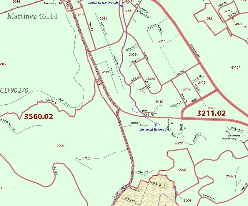
That will take you to the California 2010 Census Block Maps – Place (In my case, for the property I was researching)
Select the tab corresponding with the first letter of the city and then select the “Place Map”. In this case, I selected “Martinez City”, which takes me to another page with pdf files of maps with CBG defined boundaries. For Martinez, there are 5 maps, but there is no apparent way to find a particular map by address. You simply have to open them to manually find your property and which CBG it is in. Randomly picking through 5 maps is not too bad, but larger cities would be difficult; Los Angeles has 119 maps.
My property is located in the 3211.03 Census Tract and within that tract, there are numerous CBGs that are in the 2000’s.
The 2000’s is where I believe CU will be focusing on location to determine a potential properties locational similarity.
Keep in mind “Location”, for Collateral Underwriter, will be a primary and highly emphasized parameter for comparable selection.
Ok. That was the long way. Just like learning math, we are all taught the manual way to do things, but a “calculator” makes it an easy job.
In this case, that “calculator” is Google.
You can use Google Earth to see the outline of all census block groups in the area using their kml files at https://www.census.gov/geo/maps-data/data/kml/kml_blkgrp.html.
Simply input the target address and Google Earth will take you from high Earth orbit, right down to your Census Block Group.
This can be a good tool to use to help you determine your comparable selection, by location, or, Census Block Group.
I do find that the Google Earth view with the Census Block Overlay is a bit tough to read. The boundaries are a bit difficult to follow for the optically challenged. The actual maps from the Census Bureau are much easier to read and follow boundaries with. An exhibit in your appraisal of the CBG map from the Census Bureau with the subject property indicated would be an excellent visual reference for a reader and user of an appraisal.Collateral Underwriter will rank sales within your subject’s CBG higher and after January 26th, you may be asked by an underwriter why sales within your CBG were omitted from your appraisal. As always, the best way to avoid these issues is explain, explain, explain.
Apple Appraisal LLC will continue to analyze and study Collateral Underwriter and will bring this info to you. If you have any questions or comments, or maybe I have gotten something wrong here, please leave a reply.
Apple Appraisal LLC is a licensed Appraisal Management Company, serving all of California and Nevada.
Related posts


